Use Ctrl F to find the topic you need
Use Ctrl + to zoom into the images
Monday 3rd March
Rivers - Lesson 8
Flooding is when a river's flood capacity is surpassed and it has overflowed its banks.
Here is a mind map of all the causes of flooding:

You must also understand the details of flood management:

And all the types of hard engineering and soft engineering:

The DEFRA (department of environment, food and rural affairs) and the Environmental Agency control flood management around the UK. They always protect densely populated areas against floods that occur less that once every 100 years (it would be unproductive if it was for larger floods as it would be above a person's lifetime, there is a low likelihood of occurrence, the strategy may have failed by the time of flood and it is very expensive). They do not protect grassland and low-production agriculture - allowing these to flood will give a river with a high volume space to break its banks, thus, avoiding flood in areas of higher hazards.
To calculate what needs to be protected they use magnitude frequency analysis:

A river is split into areas of high, medium and low risk:
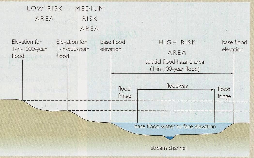
High Risk - flooding at low magnitude but high frequency e.g. every 2/5 years
Medium Risk - flooding at medium magnitude and medium frequency e.g. every 20 years
High Risk - flooding at high magnitude but low frequency e.g. every 100 years
The Thames
Facts:
·
260,000 population in Richmond, 80,000 at risk
of flooding
·
Teddington is the last point where tidal surges
affect the river
·
Farms in the UK are twice the size that average
European farm size (greatening their impact of flooding)
·
11% of UK is dense forest (deforestation increases surface run off)
Causes of Flooding:
·
Tidal surges from the North Sea up the river
·
Farming upstream
-
Empty fields for most of the year
-
Trampled soil prevented infiltration
-
Downhill contour farming
-
Causes siltation downstream as muddy water forms
streams from farms into channel
-
Increased water volume from decreased surface
runoff
Flood Management:
·
Thames Barrier to stop tidal surges
-
Used 5-6 times a year, but was only made to be
used 2-3 times every two years, by 2030 expected to be used every tidal surge
·
Embankments in Central London
-
Stops the movement of meanders and the eroding
of surrounding buildings
-
Insulated with green pathways
·
Houses with concrete air pockets and concrete
casing so it floats in times of flood
·
Houses and flats on stilts (area around stilts
is normally car parking)
·
Wetlands on the Thames Estuary
·
Floodplain management in playing fields and
parks
-
Old Deer Park opens pipe from Thames underground
to reduce volume of water in the river
Suggestions for flood
management:
·
Percentage of farms have to be permanent forest
·
Horizontal couture farming
·
Return to natural processes to stop flooding
elsewhere
Monday 2nd January 2014
Rivers - Lesson 7
Meanders and Ox-Bow Lakes

.jpg)
Depositional landforms:
1. Braiding
 |
| The Waimakariri River Brainding |
.jpg)
2. Floodplain
.jpg)
.jpg)
 |
| River Nile Floodplain |
3. Levees
.jpg)

4. Deltas
.jpg)
.jpg)
 |
| Mississippi River Bird's Foot Delta |
Monday 26th January 2014
Rivers - Lesson 6
Rejuvenation (sorry about the spelling mistake in the pictures)


Monday 19th January 2014
Rivers - Lesson 5
The Hjulstrum Curve - a diagram showing the velocity needed to perform transportation, deposition and erosion with different sized sediment in a river.

To read the graph:
- Remember that the axis are logarithmic so they increase by 10-fold on every value
- For example: for a sand particle of 0.1mm, the depositional velocity will be 1cm/sec, above this velocity it will be transported and at 20cm/sec the river will have enough energy to erode the particle
- For example: at 1cm/sec, any particles smaller than 0.1mm will be transported and above will be deposited
- Clay can theoretically never to deposited as the river will always have a high enough velocity to keep the microscopic platelets in suspension
- Clay is cohesive, so a much higher velocity than for silt and sand is needed to lift the particles in suspension (cohesive means that the particles stick together)
- A much higher velocity is needed to transport larger particles of sediment because they are heavier; boulders typically only move by traction (rolling along) and pebbles by saltation (bouncing along); these types of sediment are found at the bottom of a river, however in times of low velocity, particles as light as sand may also be found with them
- Sand particles need the lowest velocity to be transported as it is non-cohesive, fine sediment
- There are three types of load - soluble, suspended and bed
- The soluble load can't be seen as the particles have dissolved in the water, limestone and chalk are common types of rock in this load
- Velocity varies enormously along a river's course because of turbulent flow; changes in the width, depth and movement of the channel (for example, if it meanders) cause this - the graph is difficult to apply to a real river
- As the size of the sediment changes, the density (weight) will also change - the model does not take this into account
- The shape of the sediment could also effect its ability to be transported, and again this is not included
- The model doesn't question whether an increase in capacity could improve entrainment, theoretically, it would give the river more potential energy from the increase in turbulence
Friday 9th January 2015
Rivers - Lesson 4
More of the basics - sorry if you did rivers for GCSE geography.
Here is a picture of the long profile of a river and the cross profiles of three different points on this river:

Take a look at the characteristics of each of the sections labelled on the river abover:
A = Upper Course

Turbulent flow is a series of erratic eddies (spiralling currents, seen by froth on the river's surface), depending on the velocity and amount of energy lost to friction - it is estimated that 95% of a river's energy is used to overcome friction.
B = Middle Course

C = Lower Course

Laminar flow is a horizontal movement of water, in an area of the channel where then are no obstacles (this make it very rare).
The Bradshaw Model tells us how these characteristics change as we travel downstream:

The Bradshaw Model is not always correct, the discharge of a river can actually decrease as you travel downstream because of dams / reservoirs and water abstraction. A good example of this is the River Colorado in North America; it is the second largest river in the USA yet some years the mouth is dry. Why do you think this is? One of the main reasons is the human interference with the river's course, in order to, make Nevada habitable: a.k.a. making Las Vegas alive.
A graded profile can also tell us how a river varies:

You must also know why these changes occur - i.e. what effects the level of energy in a river:
It is based on the kinetic energy which is gained from the mass of water, as well as, potential energy. Increasing these factors will allow the river to gain velocity - the faster the flow, the greater the turbulence and the more sediment that can be transported as there is surplus energy after overcoming friction.

The energy of a river also contributes to the different factors which alter the size of the river's channel:

Monday 5th January 2015 - Happy New Year!
Rivers - Lesson 3
Hello everyone, sadly now that Christmas is over we all have to get back to work and today we started this by assessing the water balance of the River Wye and the River Cam.
Take a look at this data and how I have labelled the different stages of the water budget for the River Wye:

Storage = precipitation - (runoff + evapotranspiration)
Runoff % = Runoff
---------
Precipitation
Use your knowledge from previous lesson to understand why the data is like this, e.g. negative storage in summer as outputs > inputs.
We can then use a dispersion diagram to represent this data:

Remember that you earn marks in the exam for just labelling the axis and giving the graph a title.
Lower quartile = 25% boundary of data
Median = 50% or mid-point
Upper Quartile = 75% boundary
Interquartile range = middle 50% of data, calculated by subtracting the LQ from the UQ
Range = total area of data, calculated by subtracting the smallest value from the highest one
Standard deviation = a value representing the spread of the data from the mean
Here is how you calculate standard deviation:
.jpg)
Here are the positive and negative factors for dispersion diagrams and standard deviation:
.jpg)
Have Fun!
Monday 15th December 2014
Rivers - Lesson 2
River discharge is the amount of water passing a given point in the river at any given time:
Discharge (cumecs) = cross-sectional area (meters squared) x mean velocity (m/s)
It can be affected by:
- Distance downstream - more tributaries have joined the river further downstream
- Climatic characteristics - snow or rain as precipitation, higher temperatures increase evapotranspiration
- Land use - urbanisation + deforestation, afforestation
- Water abstraction - irrigation during summer months
- Channel modifications - channel straightening + enlarging
Here's all you need to know about hydrographs:


Fact: the Amazon has such a large drainage basin that its potential peak discharge is equal to the cumulative discharge of the next 10 largest rivers!
Monday 8th December 2014
Rivers - Lesson 1
Welcome to Rivers!
Our first lesson was more of an introductory lesson, used to recap over some GCSE knowledge. Look at the images to find out what we learnt.
Drainage Basin:
 |
| Apologies for the lack of colour |
Confluence - where 2 rivers meet
Watershed - the edge of a river basin
Source - the start of a river
Drainage basin - an area of land drained by a river and its tributaries
Mouth - where a river flows into the sea
Tributary - a smaller river that joins to a larger river
The Hydrological Cycle


The Water Budget
Precipitation = total runoff + evapotranspiration +/- storage (in surface and rock)
P = O + E +/- S
Soil moisture recharge - a period when precipitation exceeds evapotranspiration but any water collected helps the river to reach full field capacity that has been lost during a period of soil moisture use (typically the summer months)


The River Wye experiences a large amount of precipitation because rain clouds, which have traveled over the Atlantic, condensate when they rise over mountainous areas because of the high relief. Once these clouds reach the East of the island there is very little water left, so these areas tend to have less precipitation.
Monday 24th November 2014
Cold Environments - Lesson 11
Fact sheets:


Unlike the Arctic, Antarctica is not inhabitable so there
are no indigenous habitats that we know of; in fact the only groups that live there
are scientists. The Antarctica is the most remote continent on the Earth and
its giant ice sheet, which is around 2000m thick, has created a fragile
environment - home to penguins, seas, algae and abundant wildlife.
Timeline of human activity:
1700s – Seal exploitation begins
1800s – Fur seals are virtually eradicated around the
Falkland Islands so activity moved to the South Shetland Islands; within 3
years 300,000 seals were killed
1800s – Whaling becomes popular: Blue and Right Whales were
hunted with harpoons for oil and whalebone (baleen), there was no thought for
the future; Gryviken, in South Georgia, was one of the major whaling stations, used by Norway, USA and UK
1946 – International Whaling Convention was established
1959 –
Antarctic Treaty created, being signed by 12 nations
1964 – Agreed Measures for the
Conservation of Antarctica Flora and Fauna (suspended in 1988)
1972 – Convention on the Conservation
of Antarctic Seals – hunting of seals is illegal
1982 – Convention on the Conservation of Antarctic Marine
Living Resources (CCAMLR) established
1985 – Whaling was stopped as most nations agreed to halt
slaughter as many whale species were virtually extinct
1991 – Further environmental protection was added to the
Antarctic Treaty to monitor and minimise human activity
1998 – The Protocol on Environmental Protection added to the
Antarctic Treaty
2014 – 45 nations have signed the Antarctic Treaty,
representing 2/3rd of the world
Environmental issues:
- Fishing
Several species of fish have been
over-fished, for example, the Russians and Japanese contributing to the 100,000
tonnes of Krill per year. Krill are tiny crustaceans near the bottom of the
food chain, meaning that the whole marine environment depends on them. They are
being caught for animal feed, aquaculture, bait and human food.
Also, global warming has been affecting
phytoplankton, on which Krill feed – this again has devastating consequences
for the food chain.
CCAMLR are trying to find a sustainable way
to fish while preserving ecosystems; they have been doing this by monitoring
activity and wildlife, creating catching limits, closing areas from fishing, as
well as, improving fishing practices
2. Tourism
Antarctica gets 30,000 visitors a year;
these visitors are split into 3 categories:
·
Camping – journalists, naturalists,
photographers
·
Ships – cruise ships tourists
·
Over flight – however, this was stopped for the
last 20 years due to a crash on Mount Erebus (Antarctica’s highest mountain)
that killed all passengers
As part of the Antarctica Treaty,
visitors must follow strict guidelines to minimize impact on the wildlife:
·
Protect the wildlife (don’t scare, touch, feed
etc.)
·
Respect protected areas (alien bacteria could
destroy the fragile ecosystems)
·
Respect scientific research
·
Be safe
·
Keep Antarctica pristine
IAATO evaluates tourist
activities to minimize environmental impacts. It was started by tour operators
who wanted to teach people about the environment but still protect the
beautiful habitats; it now has 100 member companies from many countries around
the world.
Antarctica is one of the most protected wildernesses in the
world, which is why the presence of tourism and fishing has to be handled
sustainably. Although, the income created from these businesses can’t benefit
the continent, as no one lives there, it could be used to aid conservation or
to educate the world about its precious nature.
The Antarctica Treaty:

The Treaty also insures that Antarctica should only be used
for peaceful means, therefore, any military or nuclear activity is prohibited.
Looking towards the future, Antarctica’s biggest threat is
climate change, as the seas around the ice sheet become warmer, the ecology of
the entire region will be affected. If the Antarctica ice sheet begins to melt
the whole world will feel the effects because it holds 70% of the Earth’s fresh
water.
Monday 10th November 2014
Cold Environments - Lesson 10
Living in periglacial environments is a gruelling task, as we discovered last lesson. When human activity takes place in the periglacial areas permafrost is severely damaged. Consequently, increasing climate change because when permafrost melts, methane gas - which was stored in the ice from dead organisms - is released; being a prominent greenhouse gas, methane warms the air and promotes the further melting of ice.
Shocking facts:
Evidence has now been found that permafrost temperatures are warmer closer to the surface, but should be warmer nearer to the centre of the Earth.
If temperature increase continues at the same rate by 2200 2/3rds of total permafrost would have melted.
We just recapped over last lesson and discussed the effects of human activity in glacial/periglacial environments, feel free to look up graphs showing human activity across the world - this may come up in the exam - here's one to get you started:

Monday 10th November 2014
Cold Environments - Lesson 9
The last periglacial landform: pingos. Here is a diagram explaining all you need to know about their formation.

Friday 9th November 2014
Cold Environments – Lesson 8
The tundra biome is a large naturally occurring community of
flora and fauna occupying a major habitat in a periglacial environment. Facts
that would impress the examiner: 50% of Canada is tundra, temperatures don’t
exceed 5 degrees Celsius (coldest biome on Earth) so there is permanent
permafrost and during the summer there is just under 24 hours of daylight (this
is because the sun travels parallel to the land rather than perpendicularly).
 |
| Tundra |
Despite the harsh conditions of the Tundra:
·
Very low temperatures
·
Short summer, consequently a short growing
season
·
Low precipitation: between 6-10 inch a year
(‘cold desert’) but the tundra is a moist environment as the permafrost creates
poor drainage and low temperatures slows evaporation = rich wetlands and
constant fog during the summer
·
Thin, stony, poorly developed soils: high winds
dry the surface and move dust/snow
·
Permafrost
·
Surface thawing in summer causes waterlogging
·
Long periods of lying snow
·
Blizzards
· Limited food
Indigenous people (1.3 mil in 370 settlements e.g. the Inuit
in Canada and the Sami in Scandinavia) have been able to live sustainably in
their environment. These people have adapted their way of life to cope with the
climate and use their scarce resources efficiently. The Sami follow the
seasonal movements of the wild reindeer that provides them with the food and
materials that they need; they also use fishing to supplement their diets.
Similarly, the Inuit hunt seals on the frozen land and sea ice during the
winter, while during the summer – when the ice thaws – small boats are used to
fish in the open waters. All of this was completely SUSTAINABLE.
 |
| Inuit Community |
For thousands of years, the rich finishing ground of the
Arctic Ocean has been shared by indigenous people and surrounding countries.
Northern European nations (UK, Norway and Iceland) generated huge profits from
whaling and cod industries. During the last 100 years, exploitation of the
tundra has created geopolitical concerns across the world. Economic activity,
such as:
·
Sealing
·
Whaling
·
Hunting (for meat and fur)
·
Mining (particularly for gold)
·
Oil and Gas exploration e.g. the Trans Alaska
Oil Pipeline
·
Production of hydro-electric power
·
Fishing
·
Tourism e.g. holiday cabins in Northern
Scandinavia
·
Bombing ranges e.g. the former Soviet Union used
the Arctic as a nuclear testing ground
·
Wind farming
·
Transportation e.g. the Alaska Highway
Has completely disrupted the environment and the lives of
the indigenous people. The industrial developments have interfered with the
migration and hunting of Caribou, threatened ecosystems, encouraged overfishing
and enhanced the process of global warming. The effects have been even more
significant because the tundra is a fragile environment. Due to the short
summers, plants only experience a short growing season meaning their rate of
growth is very slow, when there is a disruption in the ecosystem it takes a
long time to be corrected. Species find it very difficult to adapt to a
changing environment as plants are very specialised, therefore, any change has
many long term effects.
Permafrost creates many problems for construction and
engineering work, which is why, it is only due to the development of modern technology
that we have been able to exploit this type of environment:
1.
When vegetation is cleared from the surface,
insulation is reduced causing the active layer to deepen (from melting) during
the summer
2.
Building speeds up this process by spreading
heat into the ground – thawing ice is a type of ground subsidence and creates a
thermokarst environment (extensive area of irregular, hummocky ground
interspersed with water hollows)
There have been ways to protect the permafrost but the
construction of these methods are more expensive:
1.
Smaller buildings are elevated above the ground
on piles driven into the permafrost, this allows air to circulate and remove
heat
2.
Aggregate pads (1-2m thick layers of coarse sand
and gravel) are placed under large structures to reduce heat transfer from
buildings to the ground
3.
Utilidors (insulated box elevated above the
ground, carrying water, heat and sewage pipes) so pipes are not buried underground
and damage the upper layers of soil
I know this all seems a bit boring but knowing information like
this during the exam will allow you to really show off and prove to the
examiner that you are a top grade student
It is very important that there are conservation techniques
in place for such an important wilderness area because the tundra:
·
Contains a range of exploitable resources
·
Allows scientific study of the ecosystem
·
Destruction would increase the effects of global
warming
·
Contains specialised organisms whose ecosystems
are very fragile
An example of such conservation is the National Interest Lands Conservation Act of 1980, which protects a
designated area of Alaska.
The tundra is well known for its lack of trees, Tunturia is a Finnish word for ‘treeless
plain’. The permafrost makes it
difficult for plant roots to penetrate
the soil; the strong winds causes lots of damage to the plants; and the cold
temperatures slow down decomposition, thus, there is a limited amount of
nutrients in the active layer. However, there is a variety of smaller
vegetation that grow in the environment: dwarf shrubs, grasses, mosses and
lichens.
Tundra vegetation has developed many adaptation to survive
the harsh conditions:
·
Small size, reduces the damage of the wind and
allows them to be covered in the snow during the winter which acts as
insulation
·
Many plants become dormant during the winter to
tolerate the cold temperatures so they do not use energy
·
Plants have adapted to grow quicker during the
summer months as they react to the increase in soil temperatures when the
ground thaws
·
Increasing heat efficiency by slowly moving
during the day to position themselves towards the sun
·
Protective coverings, e.g. thick hairs, to
protect themselves from the wind, cold and desiccation (extreme drying)
·
Unlike plants in the UK, some types of tundra
flora retain their old leaves to conserve nutrients and provide protection
against the elements
Lastly, there are very few large animals in the tundra as
only certain species are able to live in this type of biome. Common animals
include: lemmings, voles and shrews – due to the large of amount of these small
rodents, predators (such as artic foxes and snowy owls) are also situated here.
 |
| Arctic Fox |
Well done! You got through it, just try to remember as many
facts as possible, you could even research the Trans Alaska Oil Pipeline to
supplement your learning of human activity in cold environments. An argument
question about human activity is likely to occur in the exam.
Monday 3rd November 2014 (it’s nearly Christmas)
Cold Environments – Lesson 7
Here are some key terms that will make this blog entry much easier to understand:
Permafrost –
permanently frozen ground where soil temperatures have remained below 0 degrees
for at least 2 years
Continuous permafrost – this is found in areas where summers are so cold that there is only very superficial surface melting of the ground (meaning there is a very thin active layer: 0.5-1m). This type of permafrost has been estimated to reach a depth of 1400m in Siberia where winter temperatures readily fall to -40 degrees
Discontinuous
permafrost – found in slightly warmer areas causing islands of permanently
frozen ground to be separated by small pockets of talik. Mean annual
temperatures are between -1 and -5 degrees
Talik – unfrozen soil and rock
Sporadic permafrost
– found when the mean annual temperature is just below 0 degrees and summer
temperatures reach several degrees above, but, isolated pockets of permanently
frozen ground remain below the surface
Active layer – above the permafrost table (the upper surface of permafrost) summer temperatures are sufficient to melt the soil temporarily, creating a soggy and mobile layer. The thickness of this layer depends on latitude and vegetation cover

A periglacial environment is an environment on
the edge of a glacial environment, they are found on the fringes of
polar/glacial environment; for example, in parts of Serbia, Canada and
Greenland. They are characterised by permafrost.

As you can see from the image above, the thickness of the
permafrost decreases as we move away from the Arctic circle, showing the gradual
warming of the planet towards the equator. Permafrost is most extensive in
Russia, while less so in Canada and is not present anywhere in Europe apart from Norway. Continuous permafrost covers all but the southern coast of Greenland, it
may become less prominent in the future as global temperatures continue to
rise. This may all sound really simple but with a few figures, this paragraph
would award you full marks in the exam.
Already this seems like a lot of information but we do have
a 2 hour lesson on a Monday so get ready for even more on periglacial landforms.
Frost shattering is a very significant process in a
periglacial environment (if you can’t remember this or other types of
weathering look back on the physical geography page where it is explained in a lot of detail).
When rocks are broken apart from the landscape they become scree (sediment) and
create a rock-strewn landscape called a felsenmeer. This type of landscape is
found at the bottom of slopes and is more extensive when there are diurnal
(daily) temperature fluctuations as frost shattering happens quicker. However,
weathering can also operate over a long period of time if freezing and thawing
only occurs seasonally.
Nivation hollows are also formed in periglacial landscapes. Nivation = weathering + erosion; to creates a hollow frost heave and frost shattering break away underlying rock, then surface water is able to transport the rock to reveal an ever-enlarging hollow. If the debris becomes saturated it collapses due to the force of gravity and slumps over the hollow, thus, eroding it even further. Nivation hollows are only able to form on a slope where temperatures fluctuate above and below 0 degrees so that meltwater is present.

Solifluction (such a strange word) is the term to describe
how rock and soil move downslope due to the force of gravity. It only occurs
in areas that experience significant summer melting (so that scree can become
saturated with meltwater and the active layer can defreeze). Slow movement of
this material downhill will form lobe shaped features called Solifluction lobes
– just think of giant tongues forming on the side of a slope. If you want to do
some research into this landform Yukon, Canada would be a good place to start.
We finished the lesson with ice wedges, patterned ground and stone polygons / stone stripes. Here is a diagram telling you all you need to know:

Just remember: Wild
Penguins Go Sliding – ice
Wedges, Patterned Ground, Stone polygons
Monday 21 October 2014
Cold Environments - Lesson 6
We have finally learnt the wonders of meltwater, and I'm going bestow this information on you. Fluvioglacial means glacial meltwater so fluvioglacial landforms are formations created by melt water and fluvioglacial material is sediment deposited by meltwater streams (this is sorted by the changing powers of the water, unlike glacier till). Easy right, read on to find out more...
Why meltwater is so important:
- enlarges nivation hollows to become corries
- lubricates glaciers to overcome friction
- transports moraine so that it acts as an abrasive tool
- refreezing causes plucking to break rock from the bedrock
- erodes channels to form rivers on top and below the ice, depositing eskers
- creates pro-glacial lakes at the snout of glaciers

Terrace: infilling of a marginal glacial lake so that when the ice melts the kame is an abandoned ridge on the valley side
Delta: when a stream deposits material while entering a marginal lake to form small mound-like hills on the valley floorKame: fluvial deposition of sediment in surface crevasses so that when the ice melts they are deposited on the valley floor as small hummocks (hills)
Here are some key words that you should know for this lesson:

If there is anything you don't fully understand, please comment below and I will endeavour to help.
Monday 13th October 2014
Cold Environments - Lesson 5
When a glacier retreats it leaves
behind a variety of depositional landforms. These are formed from huge
quantities of sediment called moraine (material that is carried by a glacier) –
this sediment may be from frost shattered rocks, scree or rocks eroded from the
ice by plucking.
There are five types of moraines:
·
Lateral –
sediment on the side of a glacier
·
Medial – middle, occurs when a
tributary glacier joins to the main channel
·
Englacial –
sediment trapped in the ice
·
Ground –
material that grinds along the base
·
Terminal –
at the end of the glacier, marks the furthest extent of the glacier’s movement
To remember this: Later Me and Terry will Eat Glaciers – try your own anagram so that these types of moraine are
easier for you to remember. Striations are lines that have been formed by moraine abrasion on the bedrock; they show us the direction of glacial movement.
.jpg)
In post-glacial periods melt
water deposits fine grain material to form new, flat land: this is named an outwash
plain. It is a vast expanse of sand and gravel. The south coast of Iceland has
been expanding due to this deposition. It has created a smooth edge to the island, instead of the jagged mountainous edge that had been there previously.

Glacial till is deposited on top
of ground moraine once a glacier melts. Till is poorly sorted sediment, unlike
rivers (which move different sizes of sediment depending on the power of the
water), glaciers are not able to separate small and large sized sediment.
Braided rivers are created from the deposition of this sediment by melt water at
different times, creating islands between streams. Meltwater carries glacial
flour (very fine, light sediment) which is why it has the iconic milky
blue colour.
Here is an example of river braiding in Iceland:

Look at the images below to
understand what this looks like:
.jpg)
Drumlins are also created by deposition; they are egg shaped hillocks which normally occur in clusters, called swarms. Take a look at this annotated diagram to find out how they form:

Similarly to rivers, it is very
important for both erosion and deposition to occur in the glacier system.
Make notes and draw diagrams about this page to expand your understanding of
these landforms, you could even search for images of ‘real life’ examples, try
these: Clew Bay and Jameson Lake Drumlin Field.
Monday 6th September 2014
Cold Environments - Lesson 4
Today's topic was glacial landforms:
- Glacial troughs
- Truncated spurs
- Ribbon lakes
- Hanging valleys
- Corries
- Arêtes
- Pyramidal Peaks
A glacial trough is a U-shaped valley that has been created from the eroding powers of a glacier. During a glacial period the power of the glacier would have cut off interlocking spurs


How does a glacial start?
A corrie develops on high mountain slopes where snow accumulates and, under pressure, creates ice. The force of gravity causes it to move downhill. This occurs on a pre-glacial hollow which has been enlarged by nivation. Once the glacier reaches its optimum weight (from the continuous accumulation of snow) it begins to flow downhill, creating a rotational movement towards the direction of flow, causing the ice to scope out the land below. Also, as the glacier moves downwards plucking and frost shattering occurs on the back wall of the corrie, increasing the gradient and producing scree (a type of sediment) which is then trapped in the ice and used as an abrasive tool. Where the land levels out further down hill, the erosive powers of the glacier diminish due to compressional flow and a small rock lip is developed from deposition. Once the glacier melts, water can be collected in a corrie and form a lake, called a tarn.

If two river valleys were supported by the same upland during pre-glacial times, it is called an arête - put simply, two corries have formed next to each other. If three or more glaciers are created it is called a pyramidal peek, there are only four of these in the world.

If we look at a real life example of these landforms they have very prominent features that make them easy to locate on an OS Map. Can you spot them?

Monday 29th September 2014
Cold Environments - Lesson 3
Today’s learning objective was to
understand about the movement of ice. It is much more complicated than just
gravity and meltwater.
There are two types of glaciers:
• Temperate
/ Warm-based glaciers
- Found
in alpine environments
- Their
temperatures are around freezing
- They
move faster than polar glaciers, consequently, causing more erosion
• Polar
/ Cold-based glaciers
- Found
in polar environments
- Their
temperature is far below 0 degrees, all year round
- Due
to such cold temperatures, freezing attaches the ice with bedrock, creating a
slower flow
Here is a detailed drawing of basal
sliding, internal deformation, glacial processes and the variations in the rate
of flow:

Controlling factors that effect ice
movement:
1. Gravity
This downhill force encourages ice to
move; the steeper the gradient, the faster the movement.
2. Friction
In order for the ice to move, the force
of friction has to be overcome. There is more friction at the base of the
glacier than at the top.
3. The
Mass of Ice
The heavier the ice, the more potential
energy it has for movement. However, more force is needed to overcome the extra
friction from the increase in weight.
4. Meltwater
Meltwater is an important part of basal
sliding. The increase in pressure from an obstacle's upslope causes the ice to
melt so that it can be used as a lubricant to overcome the obstacle.
Unlike rivers, glaciers are able to travel uphill. Meltwater is also able to
release pressure and help overcome friction.
5. The
Temperature of the Ice
Polar and temperate glaciers perform
different types of ice movement. Basal sliding occurs more with temperate
glaciers because the higher temperatures allow the ice to melt. Whereas,
internal deformation can occur in either glacier type and normally happens at the
same time as basal sliding. It occurs in polar glaciers because the cold
temperatures cause the base of the glacier to freeze to the bedrock, making it
travel much slower than other ice crystals. Here is a picture of internal
deformation, you can see the different layers of snow, which fell at different
periods, slipping past each other:

Extensional Flow – a sudden increase in
gradient will cause the snout of the glacier to move faster and become thinner,
allowing it to stretch. This cause crevasses.
Compressional Flow – a reduction in
gradient further down the glacier will slow the ice and cause it to pile up,
any crevasses will now be compressed.
Between the two zones of extensional and
compressional flow, the ice moves in a rotational manner. Moreover, the fastest
flow of ice is towards the centre because the ice crystals here are not
effected by the friction exerted by the valley.
You can also see in the drawing types of glacial erosion:
Plucking / Quarrying
This occurs when the refreezing of melt
water freezes part of the underlying bedrock to the base of the glacier. When
the glacier moves, any loose rock fragments are plucked away from the surface.
This is more common after a release of pressure when a glacier flows on the
downhill slope of an obstacle.
Glaciers acts as giant conveyer belts.
The sediment (moraine) is transported with the ice and is deposited
when the glacier melts.
Abrasion
The presence of angular, frost-shattered
rocks are carried by the ice and scratch the bedrock to form striations (these
are useful indicators for the direction of flow of a glacier). These rocks
scour the landscape until they become pulverised by the weight of the glacial
ice to become fine rock flour, which is able to smooth and polish the
underlying bed rock.
We can see these processes in roche moutonnees:

We also studied types of weathering (weathering is defined as the breakdown or disintegration of rock in its original position):
Frost Shattering
Water (meltwater or rainwater) seeps into
cracks and pores into rocks. When the temperature drops below 0 degrees, the
water freezes and expands by a volume of 9%. The expansion, exerts stress
within the rock and enlarges the cracks. When the temperature raises again, the
water thaws and more flows into the crack. Over time, this process of freezing
and thawing causes cracks to become so enlarged that chunks of rock break away
to fall to the foot of the slope as scree or travel with the glacier as moraine.
There are four types of moraine: medial (these show how many tributary glacier
joined the main glacier once it melts), lateral (erodes the surrounding rock and shows the
height that the glacier once reached along a rock face – they look like bath
water rings), englacial (carried within the glacier) and ground (sediment at
the bottom of a glacier which erodes the valley). Frost shattered rocks are very
angular and sharp, if trapped in the ice they become abrasive tools and help
break up the landscape’s surface, ready for glacial erosion.
Carbonation
This is a process of chemical weathering
where carbon dioxide is dissolved in water to form a weak carbonic acid. This
reacts with the calcium carbonate in rocks to form calcium bicarbonate, thus,
eroding the calcium carbonate (this mostly happens in limestone). The lower the
temperature, the more effective the process of carbonation will be; it is a
very important process with polar glaciers. This reaction causes the rock to
break down and disintegrate.
There was a lot of content in this lesson, so I hope that I have presented it in a way that is clear for you.
Monday 22nd September 2014
Cold Environments – Lesson 2
Glaciers – fun, fun(!) Just kidding, they are actually quite
interesting and I am here again to bestow the information that we learnt about
them. Firstly, the definition of a glacier is a slow moving river of ice and it
has to be 0.06 miles squared in area and 164 feet thick. The largest glacier in
the world, Lambert, is in east Antarctica (interesting fact: Antarctica holds
85% of Earth’s ice). Glaciers are found in alpine and polar environments, otherwise
known as glacial environments.Cold Environments – Lesson 2
How does a glacier form?
%2Bbetter.jpg)
The main input for glaciers is snow; layers of fallen snow
are compressed under great pressure causing low-density ice crystals to turn
into high-density clear glacial ice. The weight of the compacted ice combines
with the force of gravity to slowly move the glacier downhill. The underside of
the glacier moves the slowest due to the strong resistance force of fiction.
The ice is so dense that weaker rocks are eroded, creating huge valleys (these
can be seen along retreating glaciers, such as Gulkana glacier in Alaska).
These valley are also very smooth because water flows into cracks in the
surrounding land of a glacier, the low temperatures cause the water to freeze
and expand – cracking the rocks. This sediment flows with the glacier, eroding
the glacier bed and flowing with the meltwater contributing to the output for
the glacial system.
You can also see on the image that the glacier is split into
two halves: the accumulation zone and the ablation zone. Accumulation is higher
when there is a net gain of ice in that year (more input that output), this is
normally during the winter. Whereas, ablation is where the net loss of ice is
greater than what has been gained. This glacial budget is supported by the
graph below. Additionally, this graph shows the equilibrium line – when
accumulation and ablation are equal – which changes according to the glacial
budget (also called the mass balance), the movement of this theoretical line
causes the snout of the glacier to advance or retreat. 
Interesting fact: for every 100m in altitude a glacier
travels downhill, the air warms by 1 degree Celsius, causing the ice to melt.
To give you a general idea of how much glaciers are retreating, here is a map:

If you would like a detailed description to this graph that
could be useful for the exam, please comment below. Remember to always use
place specific detail, now that you are doing A level names of continents just
won’t do.
Interesting fact: an ice cap is a large mass of ice,
normally in a dome shape. These ice caps are classed as ice sheets when they
are at least 50,000km squared in area. Ice sheets are constantly in motion,
slowly flowing downhill under their own weight. Ice sheets contain enormous
quantities of frozen water. If the Greenland Ice Sheet melted, scientists
estimate that sea levels would rise about 6 meters; if the Antarctic Ice Sheet
melted, sea level would rise by about 60 meters. As we learnt from last lesson,
2/3 of the UK was covered by an ice sheet during the last ice age.Next, we spent a LOT of time creating graphs based on our glacier case study: the Gulkana Glacier in Alaska (pg. 69 in the AQA textbook). If you would like to know about the data we plotted click here.
For our homework, that Mr N so kindly gave us, we have to
watch a TV show called ‘The Power of the Planet - Ice’
and answer some questions. Although some of the content is not in the syllabus,
please watch and find out extra
information that will set you apart from other geography students during the
exam.
To revise how a glacier system works, draw a
diagram similar to the 1st image, cover it up and then try to recall
as much as you can by annotating your picture, you could even time yourself.
Hopefully, this will give you a more enjoyable way to revise, rather than just
reading notes.
Monday 15th September 2014
Cold Environments - Lesson 1
Although, we all moan that the British winters are as cold as the artic, the UK is not described as a cold environment because any below 0 degrees temperatures are not constant. However, during the last ice age (2 million to 8,000 years ago) 2/3 of the UK was covered by an ice sheet. During this time there was a land bridge connecting the UK to France; sea water was stored as ice so that low sea levels allowed high sea floors to emerge. Due to rising global temperatures this ice has melted and has allowed the English channel to be formed. However, evidence has been collected to suggest that on the West coast of Denmark pressure from melt water was created under the ice sheet, eventually causing the ice to crack and release a flood of water, in a south-west direction, over the UK-France land bridge. This is labelled on the diagram:

Moreover, you can see in the image, the separations between the ice sheet, the tundra, the steppe and the forest - the latter becoming more frequent environments later in the ice age.
Furthermore, we learnt that the high relief of Scotland caused a large amount of ice to form, this ice pulled down the northern side of the island. As temperatures increased, the ice melted causing Scotland to rise from its compression in the Earth's crust; thus, creating a see-saw effect. Consequently, the southern side of the UK is sinking. This is evident from satellite imaging and rising sea levels that are creating landforms, such as the Pearl Harbour.
Humans can't live in polar environments but can settle in permafrost environments, such as the edge of Greenland. Here is a map of the four types of cold environments that exist on the Earth today:

We enjoyed this lesson because a lot of time was spent colouring (!) and we discussed the various connections to the topic in the news today. It is very important to discuss content covered in class so that it is easier to remember when it is time to revise it.
No comments:
Post a Comment